[ By WebUrbanist in Architecture & Cities & Urbanism. ]

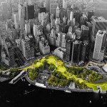
A huge infrastructure project designed to prevent future Hurricane Sandy-style devastation, the Dryline is a perfectly-named solution for a city already sporting a successful High Line and an underground Low Line currently under construction. In the wake of that devastating super-storm, over 300,000 homes were left damaged or destroyed and nearly 20 billion dollars of destruction was caused in total – the first section of the Dryline is slated to cost a few hundred million, which in contrast does not seem like so much money.


Developed by Bjarke Ingels Group (BIG), the scheme continuous to evolve with each iteration. This latest video illustrates many of the mechanisms of action through easy-to-understand sketches and diagrams. It also features interviews with New Yorkers about their vision for a greener southern tip for Manhattan.

Designed to be deployed incrementally, the grand plan involves many discrete steps, each intended to shore up the lower portion of the city – the place that takes the brunt of incoming tides. The individual interventions vary, from berms that double as parks to sliding barriers that move into position during unusually high tides. Ultimately, “the Dryline imagines a landscaped buffer stretching all the way from West 57th Street, looping down to the Battery and back up to East 42nd Street, bestowing Manhattan with a protective green cushion.”


At the same time, the design follows classic principles of urban landscape pioneers like Robert Moses and Jane Jacobs, taking this environmental challenge as an opportunity to create more park and civic space. Per The Guardian, “With a sprinkling of fairy-dust, the shoreline becomes furnished with undulating berms and protective planting, flip-down baffles and defensive kiosks, promenades and bike paths, bringing pedestrian life worthy of Lisbon or Barcelona to the gritty banks of Manhattan.”


BIG is a firm known for thinking large and this project is no exception. Then again, lessons learned from the other ambitious urban projects (like NYC’s High Line) can be applied here: built it piece by piece to reduce one-time costs and provide room for adjustment, and take citizen input into account. In the end, anyone who has walked the south edge of Manhattan knows it is a disjointed and, in many places, unwelcoming space – there is a huge opportunity for a new kind of part to provide connectivity and green space from this disparate set of urban landscapes.


“The Dryline consists of multiple but linked design opportunities; each on different scales of time, size and investment; each local neighborhood tailoring its own set of programs, functions, and opportunities. Small, relatively simple projects maintain the resiliency investment momentum post-Sandy, while setting in motion the longer-term solutions that will be necessary in the future.”


[ By WebUrbanist in Architecture & Cities & Urbanism. ]
[ WebUrbanist | Archives | Galleries | Privacy | TOS ]


You must be logged in to post a comment.