The autumn foliage of Cape Breton Highlands National Park offers a more exciting colour palette than anywhere else in Canada, and quite possibly in North America.
The best time to visit is immediately after Thanksgiving weekend in October. The holiday weekend itself can be nightmarish, with hordes of people and endless lines of tour buses. Restaurants are filled to capacity and accommodations are hard to find unless you have made reservations well in advance. On the Monday immediately following the holiday weekend, you will pretty much have the entire Highlands region and the National Park to yourself.
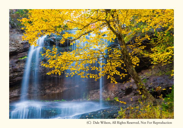
Beulach Ban Falls in the 2nd week of October.
The park is enclosed by the northern section of the famed 300Km long Cabot Trail, a loop of highway that starts and ends at Baddeck. I prefer to enter the Park at the western terminus, near the Acadian village of Cheticamp, and tour the park in a by driving in a clockwise direction along the Cabot Trail.
For those who enjoy American history, the original residents of Cheticamp are repatriated families who had previously been extradited to the United States during the Great Expulsion (Le Grand Dérangement) of 1755. The word Cajun, which is a common term used to identify the French residents of Louisiana, for example, is actually an anglicized mispronunciation of the French word Acadien. This is a topic for another day, but Cheticamp is a fabulous place to base a few days and listen to the residents speak a very unique and distinct dialect of French and English languages.
One cannot leave the Cape Breton without the classic Cabot Trail photo, and the opportunity comes early in the trip. Park your car at the Cap Rouge pull-off and look southwest back toward the village of Cheticamp – you will instantly recognize the view and potential for a great post card picture. This is an afternoon shot, unless you are looking for a photographic challenge. A sunset photo from this location can be breathtaking, but it can also be difficult to pull-off. The sun will be slight to the right-centre of the frame so you will most likely have to contend with lens flare, and make your images thinking of a final HDR treatment.
Two particular locations in the park that call me back each year are Mary Ann Falls and Beulach Ban Falls. Beulach Ban Falls is at the eastern base of North Mountain, near the most northerly point on the Cabot Trail. It is reached by way of a gravel laneway that passes a warden’s cabin, on the opposite side of the road from the Big Intervale Campground. About 2 kilometres on this gravel laneway will get you to a small picnic park, and to the base of the falls. You should hear the falls from the parking lot. As with any waterfall, the option to include the entire waterfall, or selective portions, is an entirely personal choice – let the muses direct your creativity.
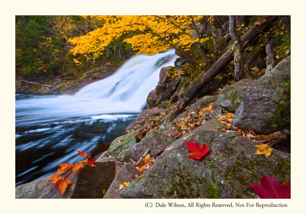
Mary Ann Falls in 2nd week of October. Yes, I placed the leaves; however, I later heard a photographer swear up and down that those leaves in his picture were exactly as he found them!
On the Park’s eastern limits, and about a 5 kilometre drive west from the town of Ingonish, you will come to a gravel road leading inland to the Marrach Group Campground. Continue along this road, following the signs to Mary Ann Falls, for about 7 kilometres until you come to a gated wooden bridge – Mary Ann Falls is immediately to your right, or downstream.
Successful images can be made at several vantage points, but the weather will often decide your ideal location along this relatively small but photogenic waterfall. Like most watercourses, the ideal time to make photographs at either Mary Ann Falls or Beulach Ban Falls is during a light drizzle or with overcast skies, thus lowering the overall contrast. Shutter speeds below 1/15th of a second should produce the often sought after “bridal veil” effect, suggesting water movement.
There are many other locations in Cape Breton Highlands National Park that deserve your attention: there is a fantastic panoramic image looking up MacKenzie River from a pull-off near the top of MacKenzie Mountain, the Coastal Trail offers some really unique Jack Pine stands (an uncommon tree in Cape Breton) as well as several vantage points for great views along the Gulf of St. Lawrence shoreline, and a really easy hike among the hardwoods of the Lone Shieling Trail.
As with most national parks, there is much to offer and explore. You simply have to allow yourself the time and flexibility to maximize your efforts in this park due to its maritime environment – if you don’t like the weather, wait an hour.
The Highlands of Cape Breton, in autumn, is a world-class destination. Plan to spend at least four days to appreciate its splendour.
Post originally from: Digital Photography Tips.
Check out our more Photography Tips at Photography Tips for Beginners, Portrait Photography Tips and Wedding Photography Tips.
Canadian Travelogue: Nova Scotia – Cape Breton Highlands National Park

Digital Photography School
You must be logged in to post a comment.