RSS
 

Posts Tagged ‘Atlas’

Geotagger World Atlas: Most Scenic City Routes Mapped Using Photo Data

16 Mar

[ By WebUrbanist in Destinations & Sights & Travel. ]

tokyo

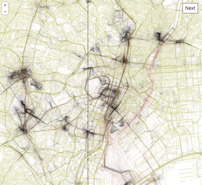
Tapping into geo-tagging data and the collective wisdom of photographers, you can use this interactive tool to follow in the footsteps of those who have mapped out the most beautiful routes through cities. Click to pan and zoom through London below:

Eric Fisher of Mapbox has spent years compiling data from Flickr users, turning their sequential geo-located uploads into paths through urban environments including San Francisco, Beijing, Istanbul and Tokyo.

san francisco

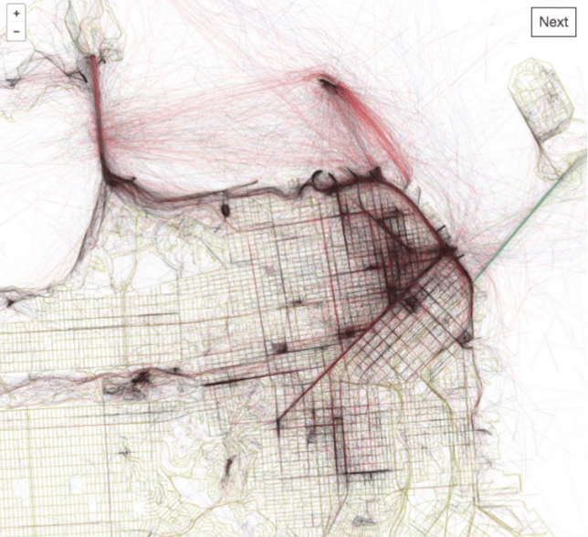
The result is the Geotaggers’ World Atlas, a data-driven compendium of paths to take through cities. It is more than just a connection of dots — Fisher’s interactive guides specifically highlight trajectories from one image to the next.

beijing

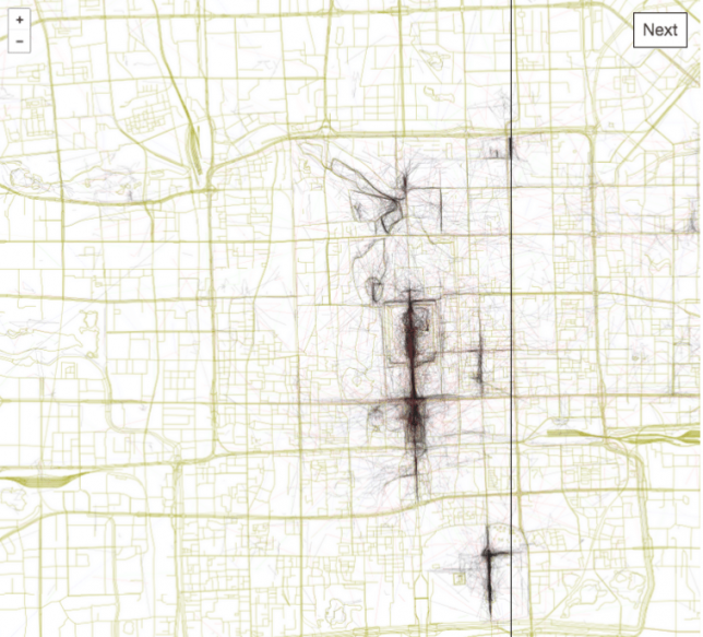
“It signifies that people went there in the first place,” he says, and “saw something worth taking a picture of, and put the extra effort into posting it online for others to appreciate. And a sequence of photos along a route is even more significant, because it indicates that someone sustained their interest over distance and time rather than taking one picture and turning back.”

istanbul

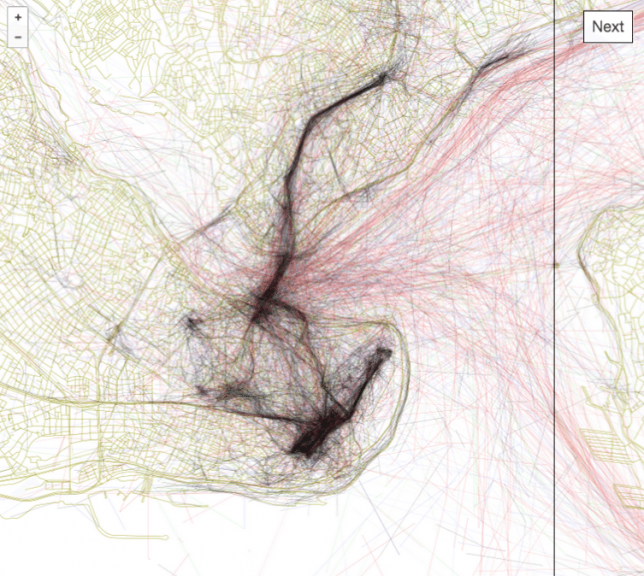
The results are predictable in some cases, tracing lines between major landmarks, but often show side routes off of beaten tourist paths where keen photographers have found fascinating architecture and landscapes worth documenting along their way.

Share on Facebook


[ By WebUrbanist in Destinations & Sights & Travel. ]

[ WebUrbanist | Archives | Galleries | Privacy | TOS ]


WebUrbanist

 
Comments Off on Geotagger World Atlas: Most Scenic City Routes Mapped Using Photo Data

Posted in Creativity


Tiny Atlas Solas ‘casual’ waxed cotton camera bag is lightweight and durable

10 Sep

Tiny Atlas Quarterly, a travel publication, has launched a new multipurpose camera bag, Solas, on Kickstarter. The Solas bag is made from waxed cotton canvas, making it both lightweight and durable, designed to be carried as an arm tote, a backpack or a shoulder bag. The Solas bag measures 17in / 43cm high and 11in / 28cm wide, while the accessories bag measures 8.7in / 22cm by 8.7 / 22cm and the lens pouch measures 6.7in / 17cm wide.

Solas is rain-resistant thanks to its waxed canvas exterior; it also features a pair of air-mesh organizer pockets and an internal key leash. The bag’s trim includes vegetable leather paired with metal buckles. An internal protective foam compartment is built-in for carrying cameras, while a padded sleeve can accommodate up to a 13-inch laptop. Additionally, Tiny Atlas says its bag features a cushioned internal frame for further gear protection.

The bag is offered in three color schemes: Natural + Yellow, ‘Color Block,’ and Black. Tiny Atlas has reached and exceeded its $ 14,000 funding goal on Kickstarter, where it offers backers an early bird bag for $ 175, among other pledge options.

Via: Kickstarter

Articles: Digital Photography Review (dpreview.com)

 
Comments Off on Tiny Atlas Solas ‘casual’ waxed cotton camera bag is lightweight and durable

Posted in Uncategorized


Clear Skies Ahead: Quest for a Complete Global Aerial Atlas

13 Sep

[ By WebUrbanist in Conceptual & Futuristic & Technology. ]

altas generation stack algorithm

If you have ever zoomed out in Google Maps (or Mapquest, Yahoo or Bing), you may have been surprised find your field of view relatively unclouded by inclement weather patterns, yet marred by strange and inconsistent seasons. Instead of a continuous satellite view, you see an apparent patchwork quilt of misfit images, incoherently stitched together.

atlas global clouded default

MapBox (which powers FourSquare among other services) is on a mission to make satellite images not only more beautiful but also more consistent and comprehensible. Their task begins with eliminating blurry landscapes, strange seams and the surreal endless summer you see on other aerial images of the globe, but the potential scope of the project goes far beyond that as well.

atlas stacked pixel maps

Talking to Wired, Charlie Loyd describes how the company is sifting through data from Terra and Aqua, two orbiting NASA satellites, to solve this problem pixel by pixel: “For the new release we’re processing two years of imagery, captured from January 1, 2011 through December 31, 2012. This amounts to over 339,000 16-megapixel+ satellite images, totaling more than 5,687,476,224,000 pixels. We boil these down to a mere 5 billion or so.”

atlas consistent cloud free

The industry paradigm is to combine parts of images representing the clearest available shots, but the result can create a clash of color from various seasons. Simply overlapping all of the different possibilities creates a mess of indistinct brown, which is not terribly attractive or useful either. Thus a middle road was found: stacking the images, sorting them by cloudiness, selecting pixels from each picture and filtering around peak growth periods. The result is a consistent yet naturally texture-rich whole both synthetic in composition yet ultimately organic in origin at the same time.

atlas mapbox future potential

The goal for now is to create a single seamless atlas that wraps the world, accurately (but with an eye towards aesthetics) reflecting what the planet actually looks like from above while also being useful in real-life mapping. Future potential iterations, however, could evolve beyond just looking and working best in traditional contexts: “If you do a web search for, say, infrared remote sensing, you’ll get an idea of the richness of possibilities, and you can start to imagine the cross-cutting inquiries that these large, open archives of multi-spectral satellite data enable,” writes Loyd. “Glaciers, wildfires, crops, droughts and floods, cities and forests, surface temperature, plankton blooms, seasonal dynamics, even smog –- it’s all there. It just needs a little work to see clearly.” 

Share on Facebook


[ By WebUrbanist in Conceptual & Futuristic & Technology. ]

[ WebUrbanist | Archives | Galleries | Privacy | TOS ]


WebUrbanist

 
Comments Off on Clear Skies Ahead: Quest for a Complete Global Aerial Atlas

Posted in Creativity