RSS
 

Posts Tagged ‘Urban’

Real Life Photoshop: Giant Eraser Takes Out Urban Scenery

29 Mar

[ By Steph in Art & Street Art & Graffiti. ]

Real Life Photoshop Eraser 1

In another case of Photoshop invading the real world in three dimensions, giant erasers are appearing all over urban surfaces in London. Murals, street signs, billboards and trash bins are among the objects getting the Photoshop treatment with ‘Street Eraser,’ a joint project by artists Guus Ter Beek and Tayfun Sarier.

Real Life Photoshop Eraser 2

Real Life Photoshop Eraser 3

Real Life Photoshop Eraser 4

The installation consists of a series of handmade stickers plastered all over the city, featuring the gray and white checkered pattern that appears when you erase something in Adobe Photoshop.

Real Life Photoshop Eraser 5

Photoshop Eraser 2

Photoshop Tools 3

A similar project used cardboard props to recreate the look of a photoshopped image in progress, with the photographer using the eraser tool on himself. Another photographer takes Photoshop tools literally with humorous interpretations of commands like ‘convert to smart object’, ‘smudge’ and ‘puppet warp.’

Share on Facebook


[ By Steph in Art & Street Art & Graffiti. ]

[ WebUrbanist | Archives | Galleries | Privacy | TOS ]


WebUrbanist

 
Comments Off on Real Life Photoshop: Giant Eraser Takes Out Urban Scenery

Posted in Creativity


Urban Jungle Street View: 3D Hack Uses Hidden Depth Data

26 Mar

[ By WebUrbanist in Gaming & Computing & Technology. ]

urban jungle street view

An explicitly illicit use of dimensional data buried in Google Street View, the Urban Jungle project adds eerie layers of post-apocalyptic green overgrowth to major cities around the world.

animated-new-york-city

urban jungle side street

As in Google Maps, a user can simply drag and drop their tiny avatar in a location of their choosing, then explore a plant-infested, tree-filled, vine-covered alternate version of reality. Click here to start exploring.

urban jungle street maps

From its creator: “This experiment using an undocumented part of Street View, the depth data. With that a depth map and a normal map is generated, which can be used in the shaders and to plot geometry and sprites in (almost) the correct position in 3d space.”

animated-street-jungle-view

street trees vines plants

Despite a glitch here or there, most locations and settings are shockingly convincing, looking like something that was lovingly crafted in incredible detail for a game (or an artist’s rendition of life after the apocalypse).

animated-time-square-signs

street view urban jungle

This otherworldly effect could just be the beginning – you too can grab the depth data at GitHub and create your own surreal landscapes or otherwise-hacked environments (samples via GMM, PSFK & PK).

Share on Facebook


[ By WebUrbanist in Gaming & Computing & Technology. ]

[ WebUrbanist | Archives | Galleries | Privacy | TOS ]


WebUrbanist

 
Comments Off on Urban Jungle Street View: 3D Hack Uses Hidden Depth Data

Posted in Creativity


Underground Urban Wonders: 7 Stunning Sub-City Spaces

18 Mar

[ By Steph in 7 Wonders Series & Travel. ]

Urban Underground Main

Far below the bustling cities of London, Paris, Montreal, New York and Helsinki are subterranean spaces ranging from dark, dank and dangerous storm drain tunnels to entire complexes complete with shopping malls and swimming pools. Some are the result of cities deciding to build down rather than out, while others remain populated only by fringe communities as officials ponder transforming them for legal public use.

Underground Farm in London Air Raid Tunnels

Urban Undergrounds London Farm

Below the London Underground, in a deep subterranean level of World War II bomb shelters, is a sight you’d never expect to see: ‘Growing Underground,’ an experimental farm producing hydroponic crops over 2.5 acres of the abandoned passages. Elevated, rodent-proof tables placed beneath growing lights coax garlic chives, radishes, watercress, coriander, thai basil and other edibles. Growing in this underground space means 70% less water is required than above-ground farming, and there’s also no need for pesticides. The operation provides hyper-local micro greens to restaurants, wholesalers and retailers within the city, and the company plans to expand into tomatoes and mushrooms.

Stunning Makeover for Paris Underground

Urban Undergrounds Paris 1

Urban Undergrounds Paris 2

What could the abandoned subway stations beneath Paris potentially hold? One city mayoral candidate is working with architects to examine new purposes for these vast, neglected spaces, including restaurants, theaters, night clubs, parks and swimming pools. They’re large, strong, open spaces with great acoustics, already located near major urban hubs, ready to be reclaimed by the public. Eight stops in total have been deemed suitable for the project, some of which have been boarded up for nearly a century.

Helsinki Underground ‘Shadow City’

Urban Undergrounds Helsinki 1
Urban Undergrounds Helsinki 2

Finland’s capital city has decided to fight sprawl by building down rather than out, building an underground city containing a swimming pool, shopping district, church, hockey rink, data center and ‘parking caverns.’ For Helsinki, this makes perfect sense (especially for the data center), as the city is built on rock that’s naturally insulating. Building down avoids the need for ugly parking decks, and also provides storage for things like coal. Officials plan to continue expanding these spaces including another 200 underground structures, new metro lines and a road tunnel project that will connect existing access roads leading into the city.

RÉSO Underground Complex, Montreal

Urban Undergrounds Montreal RESO

Montreal’s Underground City, officially known as RÉSO, is a series of interconnected spaces in and beneath the downtown area. It’s one of the largest underground complexes in the world with over 20 miles of tunnels spread over a 4.6 square mile area, containing shopping malls, hotels, condos, banks, offices, apartments, museums, universities, seven metro stations, two commuter train stations, a regional bus terminal, an amphitheater and an arena. More than 120 access points connect above-ground Montreal to this underground city. The first link began in 1962 with the construction of the Place Ville-Marie office tower and underground shopping mall, built to cover railway tracks that were considered an eyesore. The fact that the complex links so many transit stations enables Canadians and visitors to avoid nasty weather when traveling from one area of the city to the next.

Next Page – Click Below to Read More:
7 Urban Underground Wonders Active Subterranean Spaces

Share on Facebook


[ By Steph in 7 Wonders Series & Travel. ]

[ WebUrbanist | Archives | Galleries | Privacy | TOS ]


WebUrbanist

 
Comments Off on Underground Urban Wonders: 7 Stunning Sub-City Spaces

Posted in Creativity


Urban Islet: Nordic Nature Retreat Floats in London Canal

07 Mar

[ By WebUrbanist in Architecture & Public & Institutional. ]

wildlife wood finnish design

Referencing rocky Nordic island sanctuaries, this platform is designed to provide a place to relax and observe local wildlife in the heart of a bustling city. The prefabricated structure was lifted into the canal by crane and pushed into place by a tiny tugboat, all in a single day.

floating urban wildlife platform

Viewpoint was created for the London Wildlife Trust by Finnish architects of AOR. Of their inspiration: “For Finns, [small] islands are places of sanctuary, to relax the mind and get away from hectic city life. Viewpoint offers Londoners a chance to experience this escape on a secluded islet in the heart of the city.”  It is to be a permanent fixture of Regent’s Canal, located in Camley Street Natural Park.

floating islet concept context

wildlife platform floating london

As the architects alluded to, this minimalist approach and triangular architecture are modeled on the vernacular of traditional temporary dwellings found further north. Such residential retreats are situated on small islands and used for hunting and fishing excursions. Typically, these humble abodes are made using natural at-hand materials including tree bark, branches, leaves and mosses.

floating islet facade elevation

floating islet kings cross

Unveiled by the The Finnish Institute in London and The Architecture Foundation, the finished design is definitively Finnish, created with acoustics, human scale and tactile experiences in mind, and factoring in how materials will weather over time. The result features modest volumes and a warm wooden frame rising up from concrete and clad in Corten steel. In turn, this made-to-age material palette will increasingly blend the structure in with its surroundings.

Share on Facebook


[ By WebUrbanist in Architecture & Public & Institutional. ]

[ WebUrbanist | Archives | Galleries | Privacy | TOS ]


WebUrbanist

 
Comments Off on Urban Islet: Nordic Nature Retreat Floats in London Canal

Posted in Creativity


Crowdsourced City: 14 Citizen-Directed Urban Projects

06 Mar

[ By Steph in Architecture & Cities & Urbanism. ]

Crowdsourced City Main

When urban planners and developers want to know what businesses local residents would like in their neighborhoods, where to put new bike lanes, or specific areas in need of revitalization, who better to turn to than the citizens themselves? Crowdsourcing urban planning puts the future of cities into the hands of the people in all sorts of unexpected ways, from custom-designing new downtown districts to identifying problem areas for cyclists and pedestrians.

SpaceHive: Crowdsourcing Civic Projects

Crowdsourced City SpaceHive

SpaceHive is a website that crowdfunds civic projects in England, with proposals ranging from neighborhood festivals to new performance spaces in disused urban areas. It’s similar to Kickstarter, but focusing exclusively on community improvement. One recent project, the Porty Light Box, renovates decommissioned red phone booths into light boxes that display local artwork and images.

Guerilla Bke Lanes

Crowdsourced City Bike Lanes

Where do cities need new bike lanes? Officials certainly get a clue when citizens take matters into their own hands and create their own guerilla bike lanes, as they have in cities like New York and Baltimore. A group of Manhattan cycling activists called Right of Way have taken matters into their own hands, spray-painting lines and bicyclist icons just as the real thing would look (except some of the icons have wings.) In several cities, including Seattle, those DIY efforts have become permanent.

Crowdsourced Commuter Buses

Crowdsourced City Buses

While the Rinspeed microMAX is just a concept, it’s a thoroughly intriguing one: a silent minibus that relies on data points like current traffic conditions, known choke points and other info to generate a straight shot from your pick-up location to your destination. A companion app for microMAX users would enable you to find a bus in your area with a free seat, find out how long it would take to get you to your desired stop, and call for it to pick you up. Being connected to the ‘cloud’ creates an efficient, flexible and convenient transport system without wait times, prior planning or detours.

Bristol Rising: Crowdsourced City Design for Connecticut

Crowdsourced Cities Bristol Rising

How could the city of Bristol, Connecticut improve and grow to best suit its residents’ needs? Officials have gone straight to the source with ‘Bristol Rising,‘ an interactive initiative to turn the city’s flagging downtown back into a thriving destination with “a vibrant, walkable, contiguous experience.” Residents are invited to upload their own ideas and join in on discussions at the website so developers can gauge exactly what the community wants.

Change By Us: Crowdsourcing NYC

Crowdsourced City NYC

A similar project asks New Yorkers, “How can we make our city a better place to live?” The community is invited to submit ideas at the Change by Us NYC website, where a network of city leaders reads and considers each proposal. Successful 2013 projects include a new community garden and greenhouse. Ideas include cleaning and repairing existing bike lanes, new pedestrian bridges, composting locations and discounted Citi Bike memberships for low-income residents.

Next Page – Click Below to Read More:
Crowdsourced City 14 Citizen Directed Urban Projects

Share on Facebook


[ By Steph in Architecture & Cities & Urbanism. ]

[ WebUrbanist | Archives | Galleries | Privacy | TOS ]


WebUrbanist

 
Comments Off on Crowdsourced City: 14 Citizen-Directed Urban Projects

Posted in Creativity


Decoding Streets: Secret Symbols of the Urban Underground

28 Feb

[ By WebUrbanist in Global & Urbex & Parkour. ]

street paint language us

Somewhere between city signs and street graffiti lies a surprisingly rich and colorful language of secret messages, all hidden in plain sight on roads and sidewalks. This spray-painted slang we walk over and drive along every day is employed by infrastructure engineers, utility companies and other city workers.

street symbols multi colored

secret hidden street language

Laurence Cawley of BBC News recently explored this strange world of colorful spray-painted dots, arrows, text and more, all of which denote what lies below the surface of the city.

street symbols blue water

These markings may seem rushed and crude to the casual observer, but they are essential to the protection underground power lines, pipes and a maze of other potential subterranean hazards, as well as to the safety of those who work around them. There are no laws governing this mysterious language, simply conventions and colloquial shorthand that have evolved over time. As Cawley aptly summarizes: ”Its lexicon is numbers, lines and symbols. Its grammar is most definitely colour.”

street symbols white general

Colors are particularly critical – at least in the UK, red means electricity, blue stands for water, yellow is tied to gas, and green is used for cables (CCTV networks, television lines and fiber optics). White, meanwhile, is a kind of all-purpose color for broader communications about road and sidewalk planning. None of these are spelled out in any official manual in the UK – they are a matter of convention, and, sometimes, contention, as not all companies use the same visual dictionary.

street color decoder rings

In the United States, however, according to Smithsonian: “These ‘safety colors’–expanded to include red, orange, yellow, green, blue, purple, brown, grey, white, and black– have been formalized by the American Standards Institute (ANSI) as Safety Color Code Z535, which provides Munsell notation and Pantone color-matching information to help ensure consistency across mediums.”

street symbols green cables

At least back in the UK, though, numbers and arrows take on different meanings due to color and context. Sometimes they refer to the depth of a water pipe, or the pressure in a gas line. Infinity symbols may mark the end of beginning of a planned street, while zig-zags communicate an intended pedestrian crossing. Many of these are mapped out by third-party contractors whose sole job it is to locate and tag potential hazards below. All are biodegradable and many designed intentionally to fade over time.

street symbols yellow gas

street symbols red electricity

If you are looking for more specifics, the BBC article goes into detail about the particular meanings of various specific marks, but keep in mind: many of these may be particular to the United Kingdom, or even just specific towns and streets. There is no Oxford English Dictionary tying them all together … at least not yet. The next time you take a walk, consider taking some notes as well and see if you can decipher the local dialects of this curious language on your own city’s streets.

weburbanist hoboglyphs examples image

Recently popularized thanks to TV’s MadMen, hoboglyphs also come to mind – a semi-secret language of unobtrusive markings used by the homeless to note opportunities and hazards in urban environments. And one has to wonder: are there other hidden communications out there used by ancient orders, intelligence agencies or other groups hiding in plain sight? (Images via BBC and Smithsonian)

Share on Facebook


[ By WebUrbanist in Global & Urbex & Parkour. ]

[ WebUrbanist | Archives | Galleries | Privacy | TOS ]


WebUrbanist

 
Comments Off on Decoding Streets: Secret Symbols of the Urban Underground

Posted in Creativity


Civic Secrets: Urban Patterns Revealed in Street-Side Snow

14 Feb

[ By WebUrbanist in Architecture & Cities & Urbanism. ]

urban sneckdown intersection image

Ingenious and contagious, the idea is spreading: after it snows, document where cars do not go, then use that to understand where sidewalks and other public areas can be expanded without any spatial cost to vehicular commuters.

urban public space activism

Jon Geeting of This Old City shows how these so-called ‘sneckdowns’ can work after a snowstorm in Philadelphia. Starting with simple phone-camera photographs, he added colored-line highlights that illustrate actual traffic patterns. These captures implicitly suggest ways to eliminate  car parking, introduce pedestrian plazas and potentially much more.

urban snow implied space

As for the strange name, he explains: a sneckdown “is a clever combination of “snow” and “neckdown” – another name for a curb expansion – that uses snow formations on the street to reveal the space cars don’t use. Advocates can then use these sneckdown photos to make the case to local transportation officials that traffic calming interventions like curb bumpouts and traffic islands can be installed without any loss to car drivers. “

urban post snow photos

Bypassing cumbersome urban planning studies, this approach is a free, easy and highly visual way for people to first understand and then communicate possibilities for future usage to local politicians and business owners. Simple cell phone photos provide the backdrop, allowing activist citizens to argue for everything from sidewalk and green space extensions to the creation of entire urban islands, outdoor seating for restaurants or other civic functions … all in places where, as the snow shows, no one generally drives anyway.

While the phrase and phenomena are gaining all kinds of fresh traction, the idea is not new to those in the know – Street Lessons from a Blizzard (above) by Streetfilms talked about the same process a few years back, and others have discussed it before as well. With the rise of Instagram and Twitter, however, more and more ordinary citizens are snapping shots locally, tagging them and spreading the word.

Share on Facebook


[ By WebUrbanist in Architecture & Cities & Urbanism. ]

[ WebUrbanist | Archives | Galleries | Privacy | TOS ]


WebUrbanist

 
Comments Off on Civic Secrets: Urban Patterns Revealed in Street-Side Snow

Posted in Creativity


Urban Exploration Photography 101 With Miki Lansdowne

29 Jan

Urban exploration is one’s exploration of man-made structures that are typically abandoned ruins or elements of the man-made environment that are not readily seen by most people. You may have seen TV shows documenting urban exploration, but it’s not a subject we’ve really tackled in-depth at Photodoto…until now, that is. Recently, I was contacted by Miki Lansdowne, an urban exploration Continue Reading

The post Urban Exploration Photography 101 With Miki Lansdowne appeared first on Photodoto.


Photodoto

 
Comments Off on Urban Exploration Photography 101 With Miki Lansdowne

Posted in Photography


Urban Exploration Photography – Urbex

28 Jan

Urban Exploration Photography

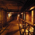
Dark halls, narrow wet cold rooms, rusted metal, chains hanging from the ceiling – it`s like you`re moving through a horror movie setting. It appears to be a pictorial journey through a strange world – a nightmarish world of shadows and darkness as after an asteroid impact.

01 black door explorerviews

Lost places, abandoned buildings and infrastructure are my favourite locations to take pictures. “Urban Exploration” also known as “Urbex” is the exploring of urban, (mostly) abandoned structures.

In this article I will tell you how I became an urban explorer, and show you how you can take pictures like you see here and on my website yourself. Hopefully you’ll be inspired to go outside to find more of those lost areas.

02 abandoned industry bretange

STEP ONE – FINDIN A LOCATION

The first step is to know the location of such abandoned places. When I got started with this hobby there was nothing on the internet about urbex or lost places. I had to search the locations for my pictures myself. But since then, a few things have changed. If you have a quick look on pages like Google Earth or FlickR you will soon find some adequate places to go. Of course you can also find them by walking attentively through the town you live in.

Ok, you have found some interesting places, and you are the owner of a DSLR or a camera to adjust exposure and aperture – now let’s get started!

03 dinner

SHOOTING

For most of my urbex photos I take more than just one picture of the same scene with different camera settings to create an HDR later, so it’s important to use a tripod. With this you can set your camera’s f-number (aperture value) to a higher level around f/8 or f/16. This affects the depth of field. Using a tripod makes it possible to take shots from exactly the same spot, important for the HDR in the post-processing.

You can manage the brightness of the exposure with the shutter speed. It’s easy and the result is a much sharper picture. For example your camera settings might look like this:

  • Aperture: f/14
  • ISO: 50/100
  • Shutter speed: variable, of course

Now you can take six or more shots with various exposure times. Sometimes three is enough, sometimes you need more than six. This depends on the differences of brightness (from shadows to highlights) in the certain situation.

The exposure time is a variable value which can not be set in a tutorial. But let me give you an example:

04 carparkingspace ben schreck

To take this indoor scene of the Car Parking Space image you see above, I took 8 different shots; the brightest one was 10 seconds (to get shadow detail) to the darkest one at 1/30th second (to get the details in the windows).

POST-PROCESSING

After the “outdoor work” is done you can start the post-processing. I take my shots in RAW Format, so I start editing in the Raw Converter. However, that is another tutorial. For the HDR I use PhotoMatix to edit the pictures.

Here you have to try different settings. I usually create a tone mapped image and save the result as a TIF file. After this I start Photoshop and the creative work begins…

In PS I work with different layers, contrast and tone correction, color changing etc. Here you have to be creative and find your own style to make your picture a unique one.

05 industry

ADDING LIGHT

To take photos in bunkers like my series of the Maginot Line, you need to bring all the light to the place by yourself. The technique is nearly the same as in a “normal” abandoned place. You will just need additional flashlights and lamps in your bag to create the lightning you want. The trick is to set up the lamps and flashlights so they do not shine directly (flares!) back toward the camera, while still brightening the space evenly.

06 maginot tunnel

07 shadow kitchen

SUMMARY

The most important part of the process is shooting at the location. That is where your photo comes into existence. You will need a little operating experience to figure out how it works. It’s all about continuing to practice and experimenting.

I hope I was able to bring you a bit closer to my way of working . More inspiration you can find on my website.

08 castle


Editor’s Note

Do have any Urbex places you’ve discovered that you’d like to share? Please do so in the comments below.

Need more information on doing HDR – check out these resources:

  • Five Minutes to Realistic HDR using Lightroom and a 32-Bit Plugin
  • 5 Tips for Successful HDR Photos
  • How to Create Realistic Looking HDR Photographs
  • Tips for Great HDR Sunsets
  • The 10 Steps Every HDR Photographer Goes Through
  • HDR and Beyond – Seeing is Believing!
  • Setting Up Your Digital Camera For HDR Shooting-Part one of a 3 part series – follow the links to read part two and three also

The post Urban Exploration Photography – Urbex by Ben Schreck appeared first on Digital Photography School.


Digital Photography School

 
Comments Off on Urban Exploration Photography – Urbex

Posted in Photography


Urban Farm Kit: Modular Chicken Coops, Planters & Benches

27 Jan

[ By WebUrbanist in Design & Furniture & Decor. ]

urban kit of parts

A solution for all seasons and regions, the premise is simple: every would-be urban farmer has space, weather and other growing constraints, and yet draws from the same set of essential needs.

urban farming exploded axon

For some folks the focus may be raising chickens and a few hardy outdoor plant varieties that can stand the shifts in weather.

urban farm detail box

For others, perhaps in colder climates, built-in storage compartments (that helpfully double as benches) and miniature greenhouse spaces may be the essential or desired accessories.

urban farm modules benches

urban farm planting platforms

urban farm system parts

A series of wooden slats rhythmically wrap the exterior, creating both material continuity between sections as well as a way to hide joints between separate pieces in plain sight.

urban farm wood wire

urban famr chicken coop

urban farming module prototype

The currently-built prototype features dark-stained natural wood and examples of most of the potential modules, demonstrating their feasibility. It includes the wired outdoor area and indoor coop for chickens, for instance, as well as a planter and a secret storage bench section.

Share on Facebook


[ By WebUrbanist in Design & Furniture & Decor. ]

[ WebUrbanist | Archives | Galleries | Privacy | TOS ]


WebUrbanist

 
Comments Off on Urban Farm Kit: Modular Chicken Coops, Planters & Benches

Posted in Creativity