RSS
 

Posts Tagged ‘Aerial’

The good, the bad and the ugly of aerial photography – Part 1: Why shoot aerials?

18 Jun

Man has always had the dream of flight – but so has the photographer. It’s a unique experience to shoot from the air, and it has some incredible benefits in many senses. But as one might discover, it often carries a number of problems and a hefty price tag. I personally started my romance with serious aerial photography about three years ago, and I’ve been hooked ever since. My experiences have mostly been amazing but admittedly not always so, and I’ve come to wonder what makes photography flights in different settings so… well, different.

In this series of articles I’ll try to survey my own experience with aerial shooting, including the different aircrafts to shoot from, what equipment to use, what technicalities to put an emphasis on and of course, the prices. I’ll talk about some of my aerial shoots, and explain what distinguished them and what I learned. Aerial photography can be wonderful and exhilarating, but it can also be disappointing if you don’t know what you’re getting yourself into. I hope the following articles help with this.

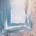
An aerial panorama of one of the most epic light shows I’ve ever seen. Wonderfully clear sun rays were peeking from between the thick cloud layer and the jagged mount Molhøgtinden and its surrounding peaks in the Lofoten Islands during my workshop there. I was stunned with excitement and couldn’t believe my eyes. After a few seconds I shook my head, picked my jaw up and went back to shooting. This image is the result.

So what makes aerial photography so darn good? A great many things. First of all, it allows for a new – and extremely different – angle of shooting. There’s a huge difference in the angle of view when shooting from the ground, or even from a mountaintop, and when shooting from hundreds of meters above the landscape. The same scenery gains another dimension, and the viewer gets a much better understanding of the surroundings. Perspective deformations are also less pronounced since there’s less of a difference in distance to the subject’s different parts.

An aerial shot of Deadvlei, Namibia. It’s incredible to realize that most of the clay pan is actually devoid of trees – which is hard to perceive when you’re down there.

It can be claimed that only from the air, one can see the landscape for what it really is. Unseen parts of the setting can be exposed, for example ones that are obscured by mountains, and with good visibility, one can see and shoot much farther than from the ground. In the image below, shot from a helicopter in Holuhraun, Iceland, several of these advantages are demonstrated: first of all, when shooting from the ground, it was impossible to get a shot of the lava which includes the caldera itself. Secondly, this angle allows for inclusion of the lava river in the background, which contributes a great deal to the composition.

In addition, some landscapes are hard to get to – not to mention shoot – from the ground, especially close enough to make them interesting. A good example of this is an erupting volcano. If the lava flow is strong, it can be impossible to go near the eruption point itself, but from the air, it can often be seen quite clearly.

But it’s really not limited to volcanoes. Instead of traversing miles and miles on foot, camping, climbing and struggling, one might take a short flight, shoot a location and fly back in time for dinner. Sounds enticing, and it truly is. Moreover, it’s quite addictive, so much so that when visiting a new location, I often feel like I have to shoot it from the air, even if there isn’t much sense in it. One mustn’t forget that aerial photography is an experience to cherish, not to be taken for granted. Do it when you must, when it offers real benefits, and not just as a means to shoot without making an effort.

The terminal of Ilulissat glacier, Greenland.

In the next article in the series I’ll talk about the two most popular aircrafts for aerial photography.


Erez Marom is a professional nature photographer, photography guide and traveler based in Israel. You can follow Erez’s work on Instagram, Facebook and 500px, and subscribe to his mailing list for updates.

If you’d like to experience and shoot some of the most fascinating landscapes on earth with Erez as your guide, you’re welcome to take a look at his unique photography workshops around the world:

White Wonderland – Lapland
Land of Ice – Southern Iceland
Winter Paradise – Northern Iceland
Northern Spirits – The Lofoten Islands
Giants of the Andes and Fitz Roy Hiking Annex – Patagonia
Tales of Arctic Nights – Greenland
Earth, Wind and Fire – Ethiopia

Selected articles by Erez Marom:

  • Behind the Shot: Dark Matter
  • Mountain Magic: Shooting in the Lofoten Islands
  • Behind the Shot: Nautilus
  • Behind the Shot: Lost in Space
  • Behind the Shot: Spot the Shark
  • Quick Look: The Art of the Unforeground
  • Behind the Shot: Watery Grave
  • Whatever it Doesn’t Take
  • Winds of Change: Shooting changing landscapes
  • On the Importance of Naming Images
  • Hell on Earth: Shooting in the Danakil Depression
  • Parallelism in Landscape Photography

Articles: Digital Photography Review (dpreview.com)

 
Comments Off on The good, the bad and the ugly of aerial photography – Part 1: Why shoot aerials?

Posted in Uncategorized


Augmented Reality: Aerial Footage of Distorted Alien Landscapes

16 Feb

[ By Steph in Art & Drawing & Digital. ]

alien landscapes 1

“Technology can help nature understand itself,” says AUJIK, a self-proclaimed cult that melds faux mythologies, fictitious landscapes and wildly distorted architecture with a philosophy they call “animism for the Digital Age.” The quasi-spiritualist Japanese collective gives us a look into the world of their imagination via simulated drone footage, swooping us over and through their vision of nature awakened in a new way by technological integration.

alien landscapes 4

aujik 14

“Since the late 2000’s, the online presence of mysterious nature/tech cult AUJIK quietly spread across video platforms featuring proposed active members and fabricated histories. These virtual appearances suggest decades-old lineage through theoretical schematics outlining their transgression emission, citing faux reports arguing the life of inanimate matter and modern forms of animism from fictional anthropologists and philosophers.”

alien landscapes 2

alien landscapes 3

alien landscapes 5

“For AUJIK, nature is divided into Refined and Primitive categories. This separation presents a conflict that is the root of all chaos in the world, and in order to reach a sublime state, AUJIK generates rituals to harmonize the organic and synthetic realms. Refined nature consists of evolved technology such as robotics, artificial intelligence, cybernetics, DNA manipulations, and body enhancements. The Primitive includes fauna, flora, and the Earth itself with its precious stones, minerals, and metals.”

aujik 12

aujik 13

aujik 11

Natural settings, rocks, plants and even living creatures become something more than themselves, infused with a new power, growing in a way that they never actually could in our current reality, bound as it is by the laws of physics. Digital forces invade and transform everything from dark forests to dense cities, warping the architecture, creating a bizarre parallel universe.

Share on Facebook


[ By Steph in Art & Drawing & Digital. ]

[ WebUrbanist | Archives | Galleries | Privacy | TOS ]


WebUrbanist

 
Comments Off on Augmented Reality: Aerial Footage of Distorted Alien Landscapes

Posted in Creativity


How to Use Drones to do Stunning Aerial Photography

22 Dec

DPSLakeSheds

One of the most exciting developments in photography in the last year or two is the drone – high flying cameras that enable you to capture unique viewpoints of common subjects. Recently the cost of getting a camera into the air has dropped dramatically and if you decide to venture down this road I guarantee you won’t be disappointed. Apart from the amazing images you will capture, they are also tremendous fun!

DPSBeetWest

As with most modern technology there is a vast range of drones, or UAVs (unmanned aerial vehicles), on the market. Similar to camera equipment in general, how much you’re prepared to spend will determine the quality of camera on-board, and the flying characteristics of the drone itself. There are low-cost models that will take very basic images, up to the big boys toys that will happily lift your prized DSLR up into the heavens. You can even add your GoPro on to some units that will take advantage of camera gear you may already have. One company has a range of models that has a large percentage of the market – DJI. Their Phantom range of drones are the first choice for many, and though they do make some high end-models, the Phantom 3 series models are the most popular drone in the world, for good reason.

Getting Started

DPSSovHIll

One of the big advertising features of most drones these days is their ease of operation. “Fly Straight Out of the Box” is a common term you’ll see, and in fact it is also very true. Charge the battery, download the app to your smartphone, fire it up, and away you go.

However, it must be mentioned that as easy as these are to fly, common sense and care is a big part of aerial flying. It’s suggested you start with some limitations in place, easily set up on the smartphone app that runs the drone. This is usually along the lines of limiting the maximum height you can fly, and also how far away you can send the drone.

71yjfeMJWwL SL1500

Photo courtesy of DJI

Always start somewhere wide open, such as a local oval or park, and spend time getting a feel of the controls before you even think about pressing the shutter button. Always be aware of your location in relation to what’s around you. As these cameras usually have a wide angle lens (20mm equivalent) and it’s easy to mis-judge your positioning when in close proximity to objects such as trees and buildings, especially if viewing the smartphone screen is your prime.

Rules and Regulations

Most countries have rules to follow, and while they can’t all be mentioned here, usually they are along the lines of these:

  • Drone must always be in Line of Sight (LOS) – that basically means you should always be able to see it
  • Maximum Height 133 metres (400 feet)
  • Never fly over groups of people
  • Respect others privacy
  • No flying anywhere near airports and other no-fly zones as specified in each country

It’s suggested you check with your local air safety authorities for particular details in your area.

DPSBurrumbeet

A few months ago I was flying above my local railway station, looking for the perfect image at dusk, just as the lights came on that illuminate the tower every evening on this historic building. Happily flying for five minutes or so, I looked down to see two local policemen coming over to me. My first reaction in these circumstances is to gauge their reaction to drone flying, and if there are any concerns I bring the machine down immediately. Unfortunately drones have been getting some negative publicity in the press, certainly not helped by the person that crash landed one on the front lawn of the White House in Washington earlier in 2015. Luckily these two policemen were very interested in what I was doing. By showing them exactly on-screen what I was seeing, and explaining the whole procedure and the care I was taking in not flying directly above any people, they left with a very positive attitude.

I think it’s very important to fly with this attitude in mind. And one other thing about flying in public places….you will need to be prepared to become the centre of attention as people are generally quite intrigued by what you doing!

DPSRailStn

Its also tempting to think that aerial imaging is going to be a great new avenue for making some money from your photography. Once again this is another area where the rules vary from country to country, and you should look into the certification you may need in your area to undertake paid aerial work.

DPSWHeip

Amazing Technology

Todays drones have some amazing technology on board that has revolutionized aerial photography:

  • By connecting your smartphone to your handheld remote control unit, you can see on-screen exactly what the drone is viewing. This makes for perfect compositional adjustments.
  • Camera controls are extensive – auto or full manual control, RAW capture, even time-lapse
  • The drone will hover in the one spot with incredible stability, almost like an aerial tripod! You can take your hands off the controls and the drone will stay in that position.
  • Failsafe flight options. With an average 20 minutes flight time per battery charge, the drone can detect when your battery is getting low and will go into RTH mode (automatic return-to-home), ensuring the drone comes back to you! If for some reason the lightbridge connection between the remote control and the machine itself is lost (this can happen when flying behind buildings or trees), once again RTH is activated. Another great use for the RTH feature is when you have lost sight of the drone, which is quite easy to do once it gets some distance away from you, by pressing the RTH button your flying camera will happily return to you before you know it.

DPSGolden

Aerial Photography

When you first start flying, it’s very exciting to get home, load your images, and marvel at the amazing scenes you have captured. In my first few weeks of flying, everything I took was thrilling. However, I quickly realized that aerial photography is no different to other forms of photography – it’s still all about the light! So rather than just heading out randomly, I once again started to chase the light and conditions, which has always been the strength of my landscape photography.

As a landscape photographer I am always aware of weather conditions and what they might offer. Now even more so, as a drone pilot you will have to also take into account the wind forecasts. Drones are not something you fly in high winds (unless you have to get that amazing once-in-a-lifetime scene in front of you!) and you will find yourself looking for calm weather more than any other condition.

DPSWindfarm

At present the in-built cameras on most drones are nowhere near the quality you are used to with your ground level camera. However, I have found the images I have been able to capture are surprisingly good. Though only 12mps, the fact that you can shoot a RAW file gives you more options to work with later on. The jpg files are also surprisingly good, especially if you have been flying in good light.

Even when shooting in low light the quality has been amazing for such a small camera unit, and the stability of the camera at 300 feet can be quite astonishing. You can also shoot panorama images just as you would when down at sea level, once again creating something very unique. And why not try a time-lapse from 300 feet?! I have had images printed up to A3 size (roughly 8×10) and you would be hard pressed to tell they were taken with a 12mp camera.

DPSGlengower

I should also mention that most drones these days shoot high quality video, even up to 4K, which produces stunning aerial footage. In fact, at 4K resolution it’s possible to take a high quality frame directly out of the video.

Unique Views

One thing you will love is the amazing patterns you find in the landscape when viewed from above. Drones allow you to get into the area that most planes and helicopters are not allowed to – below 300 feet. Google Maps makes a great starting point for finding locations that look worth visiting.

It certainly beats putting your camera on the end of a ten foot pole (yes, I did that a few years ago).

DPScanola

As a landscape photographer for a number of years now, I can’t recommend highly enough aerial imaging as a unique way to add that extra aspect to your photography. Everyone you share your images with will be amazed and intrigued, and don’t forget how much fun it is. If you ever tire of it, you may like to try herding sheep with your drone – yes, it’s been done!

Have you tried out any drone or aerial photography yourself? Please share your tips and images in the comments below.

googletag.cmd.push(function() {
tablet_slots.push( googletag.defineSlot( “/1005424/_dPSv4_tab-all-article-bottom_(300×250)”, [300, 250], “pb-ad-78623” ).addService( googletag.pubads() ) ); } );

googletag.cmd.push(function() {
mobile_slots.push( googletag.defineSlot( “/1005424/_dPSv4_mob-all-article-bottom_(300×250)”, [300, 250], “pb-ad-78158” ).addService( googletag.pubads() ) ); } );

The post How to Use Drones to do Stunning Aerial Photography by Andrew Thomas appeared first on Digital Photography School.


Digital Photography School

 
Comments Off on How to Use Drones to do Stunning Aerial Photography

Posted in Photography


Scarchitecture: Aerial Photos Reveal Vanished ‘Ghost Streets’

16 Dec

[ By WebUrbanist in Architecture & Cities & Urbanism. ]

architectural scars

When thoroughfares are subtracted from city grids, subsequent urban infill is shaped by the voids of these former roadways, streetcar or rail paths, standing out like architectural scar tissue when viewed from above. The effect is all the more pronounced when the disappeared passageways cut at odd angles through city blocks, forcing particularly odd-shaped ‘scarchitecture’ to follow.

scar detail view

When architectural writer Geoff Manaugh came across this phenomena in the streets of Los Angeles, readers rapidly began sending in examples from other cities. Some are surprisingly complex and counterintuitive, like the half-circle seen below (if you look closely) that seems to arbitrarily slice across multiple city blocks.

scar pathway winding

Manaugh’s fascination is infectious: “The notion that every city has these deeper wounds and removals that nonetheless never disappear is just incredible to me. You cut something out—and it becomes a building a generation later. You remove an entire street—and it becomes someone’s living room.”

scar horizontal slice

Perhaps most remarkable of all: many of these scarchitectural expressions frequently go largely unnoticed on the ground level. Most, however, emerge immediately as visual patterns when seen from aerial vantage points, their persistently unconventional orientations going against the grain of gridded streets surrounding them.

scar residual architecture

Small buildings can completely conform to the unusual geometries these ‘ghost streets’ trace; some sides of other structures, reconfigured paths and even parking space orientations may also follow these uncanny trajectories, in part or in whole, as if aligning to secular ‘ley lines’ of invisible force. Next time you are using Google Maps, pan around your own neighborhood and you could find evidence of scarchitecture, perhaps cutting right through your own backyard.

Share on Facebook


[ By WebUrbanist in Architecture & Cities & Urbanism. ]

[ WebUrbanist | Archives | Galleries | Privacy | TOS ]


WebUrbanist

 
Comments Off on Scarchitecture: Aerial Photos Reveal Vanished ‘Ghost Streets’

Posted in Creativity


To the skies! DJI launches Zenmuse X5 and X5R 4K Micro Four Thirds aerial cameras

11 Sep

Drone maker DJI has announced a pair of Micro Four Thirds aerial cameras including a model that can shoot lossless 4K Raw footage. The Zenmuse X5 and X5R are built around 16MP Four Thirds sensors, are compatible with a handful of small Micro Four Thirds lenses and can be flown on the company’s Inspire 1 drones. Read more

Articles: Digital Photography Review (dpreview.com)

 
Comments Off on To the skies! DJI launches Zenmuse X5 and X5R 4K Micro Four Thirds aerial cameras

Posted in Uncategorized


Hello World: Precise Aerial Art Drawn by Light-Painting Drones

11 Sep

[ By WebUrbanist in Art & Drawing & Digital. ]

dronedance

Highlighting the capabilities of high-precision aerial drones, this series of LED words and patterns could be the future of everything from midair advertising to digital fireworks displays. Entertainment value aside, there is a practical purpose behind this teaser trailer: to illustrate possibilities for 3D aeria documentation.

drones

The demonstrations in this launch video for PRENAV, a seed-funded drone venture, are meant to show potential investors and clients the power of centimeter-precise flying robots. “The precision comes from custom software and hardware we’ve created, including a robot on the ground that’s equipped with a camera and laser rangefinder to guide the drone along a predefined path.”

dronestunts

Some of these scenes were filmed in close to 20 MPH winds in the Bay Area, which is critical since the company’s mission is to document exterior infrastructure (from wind turbines to cell phone towers) for review and repair. Instead of sending people to do potentially dangerous recon, automation saves time, money and reduces risk.

droneled

“The video was a fun and playful way for us to highlight the capabilities of our system, but the precision that we’re demonstrating is essential for industrial use cases like cell tower and wind turbine inspections. For this type of work, a drone needs to fly extremely close to the structure to capture imagery and build a 3D reconstruction of the asset.”

helloworld

“Flying this close is challenging, even for the most skilled drone pilots who today try to do this manually (since GPS can’t provide the accuracy needed for autonomous guidance). Our system makes it a breeze to get complete coverage of the tower with hi-res images.  And those images then get stitched together into an accurate 3D reconstruction that can be rotated, measured, and analyzed.”

Share on Facebook


[ By WebUrbanist in Art & Drawing & Digital. ]

[ WebUrbanist | Archives | Galleries | Privacy | TOS ]


WebUrbanist

 
Comments Off on Hello World: Precise Aerial Art Drawn by Light-Painting Drones

Posted in Creativity


Amazing Aerial Photos of LA and NYC Reveal Urban Geometry

04 Aug

[ By Steph in Art & Photography & Video. ]

Screen Shot 2015-08-03 at 4.55.33 PM

No matter how far and often you might wander around your city, there’s one way you most likely never get to experience it: from above. Approached from directly overhead, the bird’s-eye-view renders virtually any urban scene unrecognizable, reducing landscaped streets and towering skyscrapers to mere shapes within an abstract composition, as if it’s a work of art. And perhaps, for some urban planners, it is. Thanks to photographer Jeffrey Milstein, we can all appreciate New York City and Los Angeles from a new perspective.

Screen Shot 2015-08-03 at 4.56.48 PM

Screen Shot 2015-08-03 at 4.56.41 PM

Screen Shot 2015-08-03 at 4.56.28 PM

Screen Shot 2015-08-03 at 4.56.03 PM

Screen Shot 2015-08-03 at 4.54.55 PM

Captured from a helicopter both at night and during daylight, Milstein’s aerial imagery of these two iconic American cities presents entire neighborhoods as tapestries of geometric shapes. New York’s Stuyvesant Town looks like a bunch of crosses embedded in greenery, and the Statue of Liberty is strikingly jewel-like on its island. 

Screen Shot 2015-08-03 at 4.53.40 PM

Screen Shot 2015-08-03 at 4.53.00 PM


Some of LA’s most posh neighborhoods are unsurprisingly picturesque from above, laid out in their carefully-arranged grids and often centered upon parks. In comparison, the shots of downtown look downright bleak, sort of like you’re looking at a circuit board rather than a full-scale city. The photographs are on display now at New York’s Benrubi Gallery and LA’s Kopeikin Gallery.

Screen Shot 2015-08-03 at 4.53.58 PMScreen Shot 2015-08-03 at 4.54.06 PM

Screen Shot 2015-08-03 at 5.52.30 PM

If looking at the pictures gives you vertigo, good, says Milstein. That’s the effect he’s going for. “That’s exactly what I want. To get a visceral reaction from it,” he told City Lab. 

Share on Facebook


[ By Steph in Art & Photography & Video. ]

[ WebUrbanist | Archives | Galleries | Privacy | TOS ]


WebUrbanist

 
Comments Off on Amazing Aerial Photos of LA and NYC Reveal Urban Geometry

Posted in Creativity


Hasselblad returns to roots with new aerial camera series, this time with no moving parts

05 Jun

Hasselblad has announced a new aerial camera that it says provides the ‘ultimate’ in image quality for aerial photographers. The camera, the Hasselblad A5D, has no moving parts and as such avoids unintentional internal mechanical movements that aircraft vibrations can cause. Read more

Articles: Digital Photography Review (dpreview.com)

 
Comments Off on Hasselblad returns to roots with new aerial camera series, this time with no moving parts

Posted in Uncategorized


Fifth Wall: Artist Uses Aerial Urban Voids as Blank Backdrops

04 May

[ By WebUrbanist in Art & Street Art & Graffiti. ]

dky art new york'

In theater, the ‘fourth wall’ refers to the imaginary barrier between performers and their audience – the work of this illustrator evokes a kind of ‘fifth wall’, treating the sky above as invisible canvass for drawing upon.

sky ladder at night

skydesign

sky people frame sun

Featured previously, French artist Thomas Lamadieu is back with new sets (SkyDesign and SkyFace) as well as fresh work in his SkyArt series from around the world, with illustrated shots taken and drawn from South Asia and Europe to the United States.

sky art cat cartoon

sky art man cat

His recognizable style is pushed in new directions as he explores difference spaces and ways of filling them in, including some cartoons that breach the sky barrier and start interacting with infrastructure and spatial elements beyond the central area of focus.

sky faces art pair

skydesign edge sitting

spacespace design series

sky art drawing sun

In SkyFace, his portraits seem to push out from their frames, filling up their allotted space and then some, pulling back buildings to be revealed. In SkyDesign, his creations begin building out their own aerial infrastructure, crafting fanciful structures in the sky and manipulating the sun, moon, stars and other celestial elements seemingly at their fingertips.

Share on Facebook


[ By WebUrbanist in Art & Street Art & Graffiti. ]

[ WebUrbanist | Archives | Galleries | Privacy | TOS ]


WebUrbanist

 
Comments Off on Fifth Wall: Artist Uses Aerial Urban Voids as Blank Backdrops

Posted in Creativity


Griddy Cities: Aerial Cyberpunk Cityscapes Shot from 7,500 Feet

23 Apr

[ By WebUrbanist in Art & Photography & Video. ]

aerial new york city

Flying over New York City, San Francisco and Las Vegas, this photographer has managed to both capture the essence of each city he shoots from the night sky above while also turning these places into surrealistic, faux-futuristic versions of themselves.

aerial new york

aerial vegas tilt shift

Using a full-body harness to hang out of helicopters, adventurous artist Vincent Laforet went to great lengths and high altitudes (in some cases nearly 10,000 feet) to take pictures of each setting (NYC and LV shown above, SF shown with making-of video below).

aerial downtown sf city

Special permission needed to be obtained to use flight paths normally reserved for passing planes. Tilt-shift techniques make the scale more comprehensible and help highlight areas of focus in each shot. What is truly remarkable, though, is how each set both reflects the photographer’s personal style but also very much embodies the character of each distinct location.

Next Page – Click Below to Read More:
Griddy Cities Aerial Cyberpunk Cityscapes Shot From 7500 Feet

Share on Facebook


[ By WebUrbanist in Art & Photography & Video. ]

[ WebUrbanist | Archives | Galleries | Privacy | TOS ]


WebUrbanist

 
Comments Off on Griddy Cities: Aerial Cyberpunk Cityscapes Shot from 7,500 Feet

Posted in Creativity